News
Fellfoot voices: Uncovering the past results
Sharing the results from the Uncovering the Past project
Fellfoot voices blog by Jodie Hannis from DigVentures
On Thursday 18 May 2023, an enthusiastic group of volunteers who have been involved in the Fellfoot Forward scheme’s Uncovering the Past programme of activities came together to celebrate all their hard work and share the results of what they’ve been up to.
Over the past two years, volunteers, local community members, and interested people from across the globe have participated in a huge variety of learning, research, activities, and events. Over 600 people have been involved, either in-person or via online events, including people from as far away as Australia, Syria, and the Philippines. It’s safe to say that this lovely stretch of the Eden Valley and fellside has enough fascinating archaeology to capture the imagination of people the world over. In this blog post, we’ll take a look at some of the results that were shared during our community evening and draw your attention to the last few events that you have the chance to get involved with.
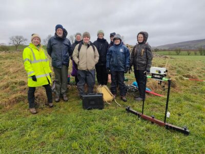
Image: Our merry crew on one of our survey days.
The Uncovering the Past project was launched with an online event in April 2021, with over 100 people signing up to get the project started. In the autumn, ‘How to Tell the Story of a Village’ got underway, with blended online and in-person learning guiding participants through conducting their own historic and archaeological research for the villages of Croglin, Hayton and Cumwhitton. We explored a huge array of material including the Cumbria Historic Environment Record (HER), local LiDAR data, and transactions of the local archaeological society journal. Participants collated their information into an easy-to-read booklet which provides an overview of the history of each village. These atlases will be free to download online and pick up from community buildings in the villages for those wishing to take a deep dive into the hard work volunteers undertook.

Image: Cover of Croglin village atlas, compiled by volunteers.
Following this, to keep us occupied over the winter months, we moved into our next course, ‘Yatters That Matter’, which introduced people to collecting oral histories and the value of capturing social history before it is lost. Participants were supported in learning how to use high quality sound recorders, techniques for oral history interviewing, and approaching transcribing audio files. Armed with their new skills and knowledge, volunteers were then able to go out into their communities and conduct interviews to form a Fellfoot Forward oral history archive which speaks to the social and cultural life of the area through recent memory. A sample of some of those recorded can be played via SoundCloud below and more of these oral histories will be available online soon.
As spring 2022 approached, the Uncovering the Past project shifted focus to in-the-field activities that would enable volunteers to explore intriguing local sites that had so far been under-researched. We started with geophysical survey days at Carlatton Cairn and Grey Yauds, where hardy volunteers joined us in the pouring rain to learn how to conduct magnetometry and electrical resistivity survey with our resident geophysics expert, Kim. We also conducted a basic condition survey as Carlatton Cairn. This, in particular, is at risk of modern disturbance that might, over time, compromise future archaeological work that could happen at the site.

Image: Our condition survey at Carlatton Cairn examined the potential risk to the site
and also started our cogs whirring about the possibility for a community excavation.
Carlatton Cairn sits within a landscape well-occupied by other prehistoric monuments in the shadow of the North Pennines. Old maps also show the ‘tumulus’ as situated close to the now lost ‘Carlatton Church’, so our geophysical survey targeted some surround fields to see if we could find any evidence that a built structure once existed here. The results of the community survey, once scrutinised by Kim and her magic interpretation skills, show several anomalies which may be indicative of former buildings, and the data shows a spread of rubble and magnetic material which might suggest a demolition event.

Image: OS map from 1864 showing the ‘tumulus’ of Carlatton Cairn and the nearby Carlatton Church.

Image: Electrical resistivity data (left) and interpretation (right) from Carlatton Cairn.
Fresh on the heels of this day out, we regrouped at our next site, Grey Yauds stone circle. This scheduled monument was once a huge stone circle comprising 88 stones, with only one surviving today. Volunteers again put geophysical survey techniques into practice and gathered valuable data that has significantly expanded our understanding of the site. The results are really quite remarkable, with several key features being identified. In the image below we can see 25 of the 88 stone sockets relating to the monument, helping us see more clearly the position and location of the lost stone circle. We also see two U-shaped enclosures which suggest there are other features and activities associated with the monument that could either be contemporary to the stone circle or might suggest multi-period use and development of the site through prehistory. The results are tantalising and generate a new set of research questions that could be tackled with further fieldwork.

Image: Geophysical survey data interpretation at Grey Yauds stone circle
hinting at a huge amount of archaeology just beneath the ground surface.
As we moved into summer, we followed up the results of our survey at Carlatton Cairn with a small-scale community excavation. With additional funding from the Cumbria Community Foundation, we were able to invite several groups of young people to join us digging and gathering further data with geophysical survey. As a team, we opened a trench running through the centre of the monument, catching a representative slice of the cairn from its middle to its outer edge. You can catch up on the results of the excavation in a previous blog post here, and how young people in the Eden Valley got stuck into their first experience of archaeology here.

Image: Some of the group of adults and young people who joined us on site at Carlatton Cairn community excavation.
The video below provides a lovely glimpse of a group of young people from William Howard School who joined us on site. We think it’s important to give young people in the area new experiences and help foster a love for their local places by spending some quality time outside (and outside school).
Our community excavation at Long Meg stone circle at the end of the 2022 season had a similar objective. We were joined by a group of young people for a day of geophysical survey within the circle, and then were able to reconvene our group of volunteers and young people from across the region to dig in this amazing setting. Young people from Tullie House Museum and Art Gallery joined us for their first experience of in-the-field archaeology, and we were also happy to host a group of refugees and asylum seekers with Multicultural Cumbria and show them the ropes.

Image: We were joined at Long Meg by an incredible engaged group of volunteers and young people
who were able to learn about how special this prehistoric site is.
This audio clip of the asylum seeker participants shows how important getting involved in local events can be for people new to the area, and how getting involved in a community archaeology project can provide much need respite from the difficulties of daily life.
Part of the project has been building a set of digital resources which means that anyone from anywhere can incorporate knowledge about the region’s archaeology into their research. As we’ve taught volunteers how to do archaeology in the field, we’ve also been showing them techniques, such as 3D photogrammetry, as one particularly cool recording method of the sites we’ve been working on. 3D models of the excavation trenches exist for anyone to interact with online for Carlatton Cairn, Long Meg and the remaining standing stone at Grey Yauds. Similarly, full reports of the work undertaken are available to read online here.
At the community excavation at Long Meg, we held a virtual site tour so that people who weren’t able to join us on site were still able to see the dig in progress. Over 400 people signed up for the virtual tour, from sixteen different countries, demonstrating that the appetite for Cumbria’s Neolithic archaeology transcends regional and even national boundaries.

Image: Map showing the online audience for the virtual tour at Long Meg community excavation.
Most recently, we mobilised at an intriguing site in Kirkoswald, in a field just south of the parish church of St Oswald, where large earthworks are visible clearly in the landscape. With local archaeologist and researcher, Andrew Pierce, we learnt about the monument’s setting within Kirkoswald village and how the original purpose and function of the moated site is largely unknown to us. We again conducted a geophysical survey and Andrew lead the volunteers in an earthwork survey, carefully mapping the topography of the ground. Combined with recent LiDAR images of the site, we get a sense of just how large and impressive the site is. Survey, of course, cannot provide us with definitive answers as to the site’s origin and use through time, but it can provide glimpses of where might be best for future archaeological research, if, say, a group of enthusiastic local people wanted to investigate further.

Image: Photograph of the medieval moated site in Kirkoswald, just to the south of St Oswald’s Church, the frosty condition and low, winter light show the earthworks in greater detail (c)Andrew Pierce.

Image: Electrical resistivity data and interpretation of the medieval moated site at Kirkoswald.

Image: Topographic survey plan created by Andrew Pierce and recent LiDAR image of the site (c)Environment Agency.
Where do we go from here? As the Uncovering the Past programme winds down, we want to invite you to participate in our last couple of events. On Tuesday 11 July, we’ll get together one last time for a day of community geophysical survey in search of a lost Roman road in the foothills of the fells. On Wednesday 11 October, we’ll be gathering at Melmerby Village Hall to strategise and explore how we can continue to support archaeological research in the area. Flagging Fellfoot Forward’s Community Grant Scheme and other local funding sources, we’ll work through some real-life examples of how to generate funding for archaeological research, including examples of successful projects, and the basics of how to cost for and plan a local project. We hope to see many of you there and, in the meantime, we want to extend our great thanks to everyone who has got involved with the project over the previous years. It’s been a joy to get to know you and the spectacular archaeology of the area, and we hope it’s the first step in many archaeological adventures to come.
Jodie, Kim, Nat, Ben, Harriet, and everyone from the DigVentures team.
You may also like

Did you know…