Visit & explore
Slitt Wood geosite
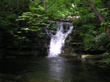
This is the beginning of a scenic 4.8 km (3 mile) walk through Slitt Wood, in the North Pennines National Landscape and UNESCO Global Geopark. The route reveals much about this little valley’s rich industrial past, which is strongly linked to the area’s geology. This is also a great place to see plants and birds, particularly in the spring and summer.
Tropical seas and river deltas
330 million years ago the North Pennines sat on the margin of a shallow, tropical sea near the equator. The remains of countless tiny sea creatures accumulated on the seafloor to form layers of hard, fossil-rich limestone, while sand and mud from swampy river deltas hardened into sandstone and shale. These rocks form the hills of the North Pennines and all three can be seen here in the banks of the stream.
An industrial past
The ores of lead and iron mined along this route owe their existence to hot, mineral-rich fluids that rose through the overlying rocks around 290 million years ago due to heat from deep underground. In the 19th century, this quiet wooded valley was a hub of industry in the heart of what is now rural Weardale. There were three major lead mines in the valley, along with bouseteems (where lead ore was stored) and washing floors (where extracted material was processed). On the hillside above Slitt Mine is a small reservoir, which stored water used to drive machinery on the site.

- NY 905 380
- What 3 Words (start of geotrail route): spurted.wanted.offshore
More to explore
Use the link below to view the visit and explore map, and discover walks, trails, activities and more across the North Pennines National Landscape and UNESCO Global Geopark.