News
Fellfoot voices: Uncovering the past in Fellfoot Forward
Uncovering the past in the Fellfoot Forward area
Fellfoot voices blog by Jodie Hannis from DigVentures
As part of Fellfoot Forward Landscape Partnership Scheme’s Uncovering the Past project, we at DigVentures have been getting to know both the wonderful community of people in the area and the fabulous archaeology, just waiting to be uncovered. We spent the winter and early spring indoors, dutifully doing our desk-based research, with activities such as the Village Atlas and Oral Histories projects, which are building a fantastic set of resources for anyone interested in the history, and indeed present, of this unique region. At heart though, I am an archaeologist who loves being outdoors, and what better place to stomp across the landscape and peer intently at the many interesting stones that are tucked away, almost everywhere you look, in the Eden Valley.
We were joined by an extremely dedicated group of hardy volunteers for two archaeological survey days in April. The rain came down but the enthusiasm stayed high. My colleagues Kim, Harriet, and Ben joined us as we investigated two sites – Carlatton cairn and Grey Yauds stone circle.
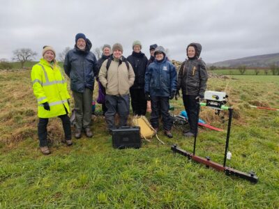
Carlatton cairn is located between the villages of Cumrew and Cumwhitton, just north of the tellingly named Cairn Beck. It is not visible from the road but can clearly be seen on Google Earth and we were very grateful for the permission of local landowners and farmers, the Mitchells, to come and investigate. We started with a condition survey where we assessed the state of the monument, took some record photographs, and considered whether the site would benefit from a small-scale targeted excavation. A pile of stones is somewhat hard to date and there is an enduring question whether Carlatton cairn is simply a medieval field clearance cairn or if it could have prehistoric origins. Similar sites tend to date from the late Neolithic to early Bronze Age and research indicates that they were important focal points in the landscape for navigation, social gatherings, and burials. They tend to be closely associated with water sources, as bubbling springs and following rivers play a key role in the symbolism of making sense of the journey of life and death.
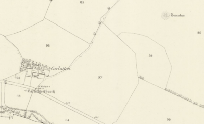
The 1863 25 inch OS Map, image from the National Library of Scotland online
In the next field, we also conducted a geophysical survey with our resident geophysicist Kim. It’s a suspiciously flat field amongst the rolling glacial hills of the valley and an early OS map shows an ‘X marks the spot’ for the site of a lost medieval church in the area. We thought our flat field might be a good candidate so our team of volunteers marched up and down in transects using earth resistivity survey to get a sneak peek of what might be going on under the soil:
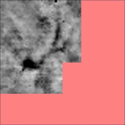
We can see some interesting earthworks and, perhaps, the whispers of a lost church. We discovered some really interesting positive (black) curvilinear and rectilinear anomalies which hint at the presence of archaeological remains – so we want to widen our survey area and see if we can make some more sense of what we’ve already discovered.
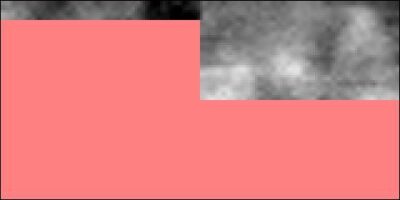
We also had a day at Grey Yauds, which was once a huge stone circle but now only one stone remains. We were really hampered by the weather and some technical difficulties, but nevertheless we managed to do a nice grid and a bit of earth resistance survey…the data shows some high resistance pockets and some low resistance pockets, but we really need to do a larger area of survey to understand what we’re looking at. Have we found some of the stone sockets? Or can we see more of the stone circle buried beneath the surface? We will come back to the site in August and will once again ask our volunteers to assemble to help extend the survey grid.
Our immediate plan is to go back to Carlatton cairn to extend our investigation with more survey and an excavation of the cairn. The monument currently shows damage as it continues to play an active role in the management and storage of stone and rubble in the landscape (some ideas and practices endure thousands of years!). We will be there Saturday 25 June to Monday 4 July and we need you.
If you’d like to take part and get your hands dirty, you can find full details of the dig here. It’s free to attend and no experience is necessary – just a reasonable level of fitness, a good set of waterproofs and a fascination for archaeology!
Huge thanks go to the landowners Robert Mitchell and Robert Craig for their ongoing support and, of course, to our team of volunteers who continue to be so enthusiastic and generous in making this project happen.
You may also like
Did you know…