News
Using digital twins in peatland restoration
20 November 2024
Using digital twins in peatland restoration
20 November 2024
Peatland restoration is a major part of the work of the North Pennines National Landscape team. It plays an important role in addressing the effects of climate change because damaged peatland releases a huge amount of carbon dioxide into the atmosphere. Putting together a restoration plan for a peatland site in the North Pennines would generally require time-consuming fieldwork and manually interpreting aerial photographs in GIS (Geographic Information System) software to map erosional features and determine the locations of restoration interventions. However, this process is labour intensive and inefficient given the vast areas of peatland that need to be restored to meet national and international targets. This is why the North Pennines National Landscape team is using remote sensing data and developing new digital approaches to increase efficiencies.

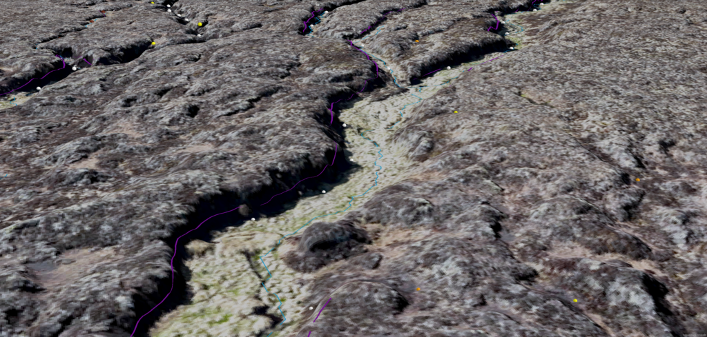
GIS & Remote Sensing Officer, Dr Miles Wilson gave a talk at the Eurosite Annual Meeting 2024 about how the team uses remote sensing datasets and GIS techniques to map drainage channels and calculate the size of non-vegetated damaged peat areas. He also introduced the innovative approaches of automated erosional edge mapping and ‘digital twins’ to better develop initial restoration plans from the desk. Taking elevation data from the Environment Agency’s National LiDAR Programme or the team’s Unoccupied Aerial Vehicle (UAV) surveys, a custom-built model in GIS software is now used to automatically map erosional edges. These mapped edges can then be incorporated into a 3D digital twin of the restoration site made from UAV data. This means that without doing a site visit, field officers can visualise the restoration site, consider whether the erosional edges are suitable targets for reprofiling and decide where leaky dams should be placed in the identified drainage channels. On a 131 hectare site, the North Pennines National Landscape team automatically mapped approximately 14 kilometres of erosional edges over 1000 potential leaky dam locations.

Miles said: “The use of digital twins in peatland restoration will play a key role in scaling up restoration efforts to meet national and international targets. Our field staff are now able to virtually access restoration sites all year round regardless of poor weather conditions and sensitive periods such as when it is bird breeding season.”
This digital approach for peatland restoration planning has many advantages. It makes the process of developing restoration plans far more flexible and it is more efficient because erosional edges can be automatically mapped in a matter of seconds whereas it could take weeks to do this manually. There is reduced foot presence on sites, which means less disturbance to fauna and flora and the risks of working alone in a remote location are minimised. Lastly, it provides more opportunity for equality, diversity and inclusion in the workplace through the creation of more desk-based fieldwork jobs.

The team is already further developing its use of remote sensing technologies and innovative GIS techniques, and in the future hopes to use more complex digital twins for remote monitoring with near real-time data from satellites and field sensors.
Find out more about how the team is using digital approaches in peatland restoration here:


