News
Volunteers learn skills to explore heritage sites
27 November 2025
Volunteers learn skills to explore heritage sites
Blog by Jenny Addis, Elder Archaeology
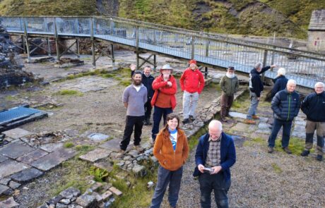
During a two-day workshop at Nenthead Mines, a group of volunteers learnt how to use modern technology to explore a historic industrial location. Elder Archaeology has been contracted to deliver a series of community heritage workshops and activities as part of the North Pennines National Landscape team’s Land of Lead and Silver project.
I started the day with a presentation on why archaeologists use drones, the basics of flying a drone safely, and the licenses required. The group then had one-to-one drone flight training from both Elder Archaeology staff and the North Pennines National Landscape team using two small drones.
Drones are excellent tools for gathering and recording data on sites and landscapes. They can be used to capture images of a site throughout an excavation and to provide aerial photographs of a completed site. Drones can also be used to create three-dimensional models of sites and landscapes using photogrammetry, as well as to produce aerial photographs for use in pre-excavation surveys and to produce LiDAR (Light Detection and Ranging) images.
The training allowed the volunteers, many associated with the mines, to discover how to use the drone to explore and create 3D digital models of old sites and buildings. They were also able to venture underground on a mine tour to learn about the site and why it’s so important to the area’s heritage.
The following day saw the same group of volunteers return for a photogrammetry workshop in which I explained why archaeologists use photogrammetry. The group learnt the basics of the software before going outside to select a feature of the mines to photograph in order to photo model.
Photogrammetry is the method of creating a virtual 3D model from a selection of overlapping photographs. The technique is increasingly used by conservators and archaeologists to record, investigate and promote heritage. Once the group had taken all their photos, it was lunch-time, after which there was one-to-one training on how to turn their photos into a 3D photo-model of the feature.
All equipment and training was provided by Elder Archaeology and the North Pennines National Landscape team. The volunteers will contribute to the recording of historic structures and remains at mining sites across the North Pennines as part of the National Landscape team’s Land of Lead and Silver project. This workshop was also run as part of Heritage Open Days.
A further workshop on using the digital mapping software QGIS (Quantum Geographic Information System) to map historic sites will be held on Thursday 4 December 10am to 4pm, at High Forest Community Centre, Sinderhope. Book here.
Part of the Land of Lead and Silver project which is led by the North Pennines National Landscape team and funded by The National Lottery Heritage Fund, thanks to National Lottery players, and Historic England.

![]()


